Chalk Creek Campgrounds
Located in the San Isabel National Forest between Mt Princeton and Mt Antero, Chalk Creek Canyon has 4 US Forrest Service Campgrounds: Mt. Princeton, Chalk Lake, Cascade, & Iron City. The San Isabel National Forest is home to some of the best camping in Colorado. Follow Chaffee County Road 162 into the canyon. There is no cell service once you pass the Mt Princeton Hot Springs. There is a small store and gas available at the hot springs if you need any last minute supplies. Several of the campsites below made our list of The 5 Best Tent Camping Sites in Colorado.
Attractions in Chalk Creek Canyon:
Narrow Gauge Trail - Located a short walk downhill from the Cascade Campground along County Road 162. The 2.2 mile (4.4 round-trip) trail follows the grade for the old Denver, South Park, & Pacific Railroad and has less than 500ft change in elevation. The east trailhead is located at the end of County Road 290.
**There are frequent rock slides in the area, and the trail may be closed at times.Cascade Falls - Located along Co Rd 162 just east of Cascade Campground.
Mount Princeton Hot Springs - Get a day pass for swimming and a hot shower.
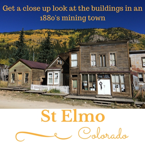
St Elmo - Well preserved 1880's Mining Town. The General Store has souvenirs, refreshments, and antiques.
Chalk Creek Trailhead connects to the 500 mile Colorado Trail. The Colorado Trail is a hiking trail from Denver to Durango.
Love Meadow Watchable Wildlife Area - Near Mt Princeton Campground
Chalk Lake Fishing Area is just west of the entrance to the Chalk Lake Campground and is an easy walk.
Agnes Vaille Falls / Cascade Creek Trail is located across the road from Chalk Lake Campground. You can see the falls from most of the campsites, just look below the V formed by the mountains on either side of Mt Princeton.

Colorado's most original ghost town, St. Elmo, is located at the end of chaffee county road 162.
Cascade Campground
Located on the north slope of Mt Antero, Cascade Campground is adjacent to Chaffee County Road 162 in Chalk Creek Canyon. Being located only 6 miles from the historic town of St. Elmo makes this one of our favorites.
If you want to reserve a campground close to the OHV trails, this is it. Iron City Campground is closer, but is first-come, first-served.
Camping Facilities:
Elevation 9000 feet.
Cell Service: AT&T-None. Verizon-None
21 Camp Sites
Picnic Tables
Fire Rings
Firewood available for purchase from Camp Host
Modern Vault Toilets (4) (Some Handicap Accessible)
Water - 1 Hand Pump located near sites 18, 19, & 20 brings extra foot traffic to those sites.
Trash Bins (3)
Sites 18 & 21 are adjacent to Co Rd 162. However, there is little traffic after 10pm.
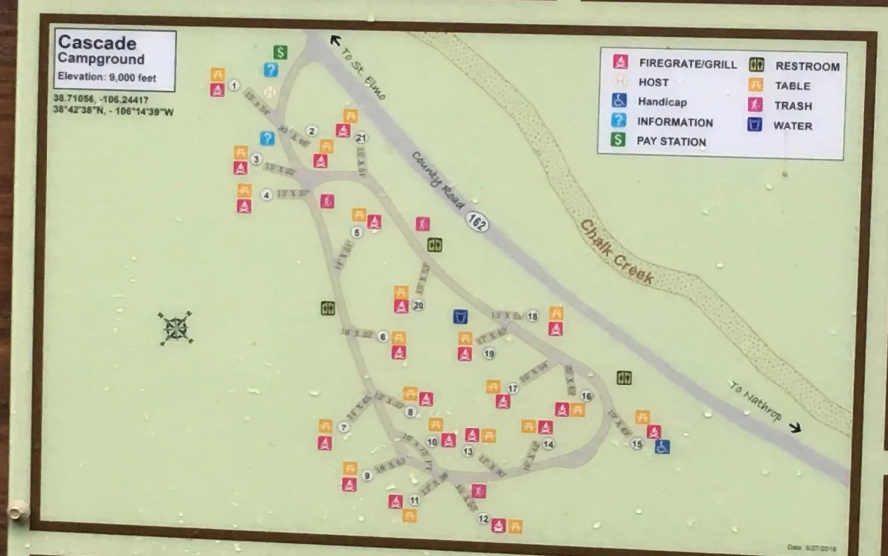

Cascade Falls - Chalk Creek is across the road from Cascade campground and the falls are located a short walk downhill.
View to SW from Campsite 18 at cascade campground
Chalk lake campground Site #13 - Campfire along Chalk creek
Chalk Lake Campground
Chalk Lake Campground is located between Chaffee County Road 162 and Chalk Creek at an elevation around 8800 ft.
Campsites 1 - 14 are creek side. Chalk Creek splits into 2 streams before reaching site 3, then rejoins around site 10. Along sites 3-9 the creek is a shallow, slow moving stream.
Sites 3-5 are less than 20 feet apart and usually the last to be occupied. Tent areas, picnic tables, & fire rings are next to the parking area.
Sites 6-9 share the same parking area, but are a little more spread out. There is a path to each site's tent area, picnic table, & fire ring.
Site 10 has it's own parking spot and would be ideal for a smaller RV. Includes a tent area.
Sites 11-14 are similar to 6-9 except the creek contains more water and the roar of the creek blocks the sounds coming from adjacent campsites. Site #13 made our list of 5 Best Tent Campsites in Central Colorado
Sites 15-19 are all individual RV sites and not shaded by trees.
Deer Eating by Chalk Lake Campground site #18. Snow covered Mt Princeton. Agnes Vaille Falls visible just above the top of the trees and below the "V"

Chalk Lake campground Sites 7 & 6. Slow flowing portion of chalk creek is next to camp

Chalk Lake fishing area is next to chalk lake campground
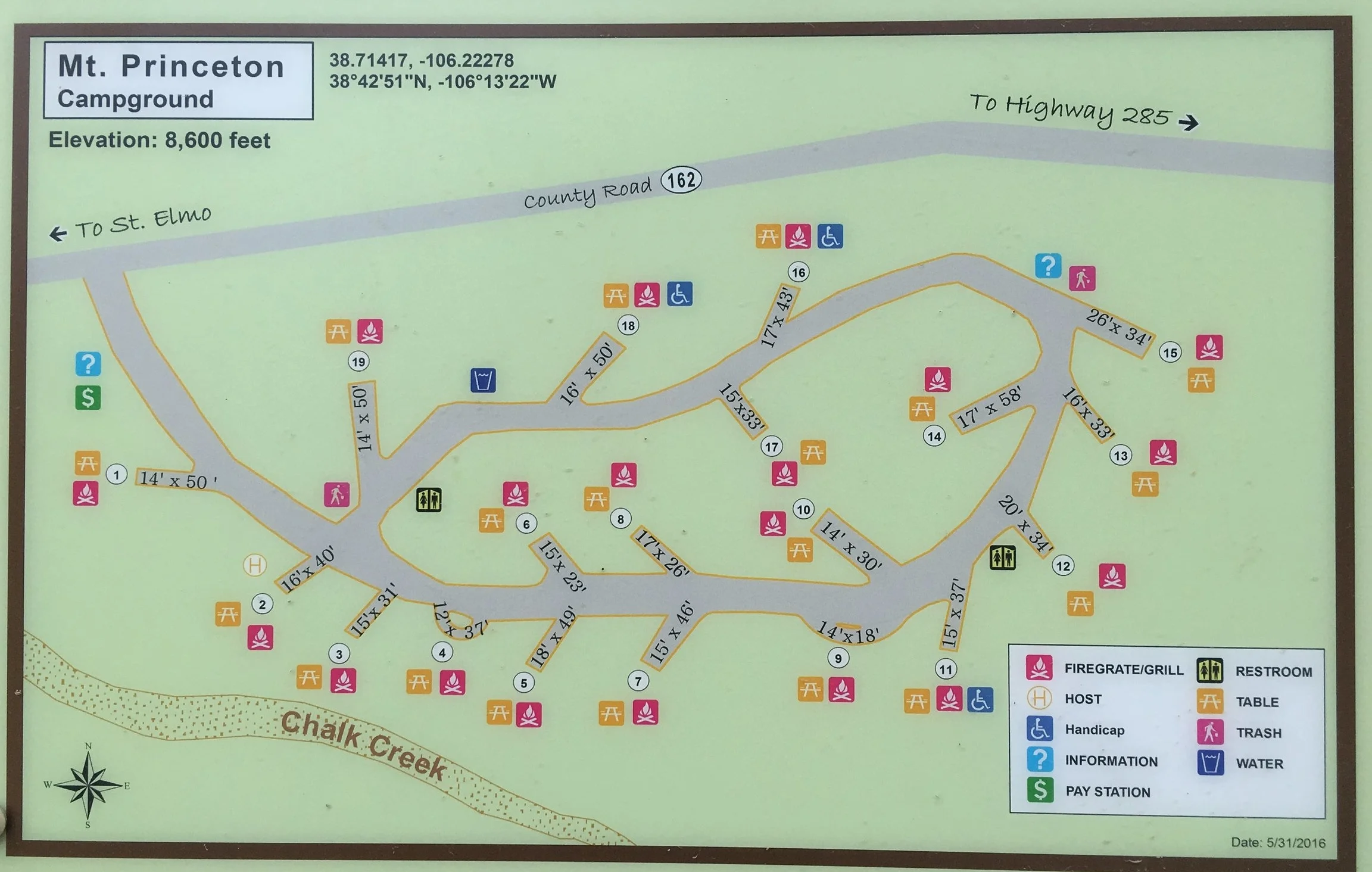
Mt Princeton Campground
Mt Princeton Campground is also located along Chaffee County Road 162 in Chalk Creek Canyon. At an elevation of 8600ft it is the first campground in the canyon. There are 18 regular campsites and 1 tent-only site. Several of these are near Chalk Creek.
Iron City Campground
Iron City Campground is located a half mile from St Elmo Colorado in the San Isabel National Forest. It is made up of 15 campsites on either side of Chaffee County Road 292. All campsites are first come first served. No reservations. There is a hand pump for water and one vault toilet near the center of camp. The road is a little rougher than other nearby campgrounds. ATV's are allowed on Co Rd 292, and this is the route they take from St Elmo to Mt Antero. The west end of the campground is near the historic Brown Cabin and the east end is next to the Iron City Cemetery.
Because this campground is on either side of a county road, it is never closed. This makes it a great backup plan when nearby campgrounds close in mid to late September.
Cottonwood Pass Area Campgrounds
Two USFS campgrounds can be accessed via Chaffee County Road 306 on the way to Cottonwood Pass.
Cottonwood Lake Campground
Cottonwood Lake & Cottonwood Lake Campground are located between Buena Vista and Cottonwood Pass. Travel on Chaffee County Road 306 about 10 miles west of Buena Vista and turn south on Chaffee County Road 343 or 344. Co Rd 343 is further east and merges with 344 after a short distance.
The 24 campsites in Cottonwood Lake Campground are located among aspens at 9600ft in elevation. There are 3 modern vault toilets.
No Reservations. First-come, first-served.
No motorized boats are allowed on Cottonwood Lake and the trout fishing is excellent.

Collegiate Peaks campground map - Click to enlarge
Collegiate Peaks Campground
Located at an elevation of 9800 feet, Collegiate Peaks Campground sits along Middle Cottonwood Creek about 11 miles west of Buena Vista Colorado. The top of Cottonwood Pass is a short drive up Co Rd 306.
There are 56 Non-Electric Campsites located on 3 loops including some creek side campsites. There are 6 modern vault toilets.
Nearby:
Ptarmigan Lake Trailhead - Less than 3 miles
Denny Creek Trail - Less than 1 mile. Connects to the Collegiate Peaks Wilderness Area.
Lost Lake Trail
Avalanche Gulch Trail
Collegiate Peaks Wilderness Area
Cottonwood Hot Springs (and pool) - Less than 5 miles
http://cottonwood-hot-springs.com
Arkansas Headwaters Recreation Area
The Arkansas Headwaters Recreation Area follows the Arkansas River from near Leadville all the way to Pueblo. 7 Campgrounds along the Arkansas begin north of Buena Vista and end not far from the turnoff to the Royal Gorge.
All 7 campgrounds are open 365 days a year.
Railroad Bridge Campground
Ruby Mountain Campground
Located along the banks of the Arkansas River at the north end of Browns Canyon National Monument. The campground was recently reconstructed and re-opened in May 2016.
The boat ramp at Ruby Mountain Campground is used by several rafting companies to launch their tours of Browns Canyon.
Campsites 1 & 12 are first come, first served. No Reservations
Campsite 10 is handicap accessible
Campsites 14-19 are adjacent to the Arkansas River
Miles of hiking trails in Browns Canyon National Park can be accessed from the campground
Hecla Junction Campground
The 23 campsites along the Arkansas River at Hecla Junction are open year round. Hecla Junction Campground has recently been renovated and is popular for fly fishing and whitewater rafting. Campsite #8 is handicap accessible.
Whitewater rafting trips in upper Browns Canyon National Monument usually end at Hecla Junction. The large parking area fills up several times a day with buses waiting to haul rafters back to Buena Vista. Hecla Junction campsites are up above the bus parking, so this shouldn't be a problem.
Salida East Campground
Salida East Campground is located a mile or 2 east of Salida Colorado along the Arkansas River and is open year-round. Most of the campgrounds in the Arkansas Headwaters Recreation Area have been reconstructed in recent years, except for Salida East. It was hard to tell where some campsites were located, due to people driving all over. Hopefully, Salida East will get rebuilt in 2019.
Rincon Campground
Rincon Campground consists of 8 campsites along the Arkansas River. Located about 8 miles east of Salida Colorado, Rincon Campground is in the Arkansas Headwaters Recreation Area along US Hwy 50.
Vallie Bridge Campground
Vallie Bridge Campground is Walk-in or Boat-in tent camping only.
16 Campsites are located along the Arkansas River in Bighorn Sheep Canyon, about 20 miles east of Salida Colorado on US Hwy 50.
Five Points Campground
Other Campgrounds in Chaffee County
Angel of Shavano
20 Campsites are first come, first served. No Reservations.
1 Group Campground that accommodates up to 100 people does accept reservations.
Located on Chaffee Co Rd 240 about 3 miles from US HWY 50 at an elevation of 9150ft.
The Colorado Trail passes thru the campground
Angel of Shavano Trailhead is across Co Rd 240
North Fork Reservoir Campground
North Fork Reservoir Campground has 8 campsites at an elevation of 11,400 ft.
A high clearance 4wd vehicle is required to drive the last 6 miles of Chaffee Co Rd 240 leading to the campground.
Monarch Park
Located along Hwy 50 about 2 miles below the top of the Continental Divide at Monarch Pass. Due to high altitude of 10,460 feet, it usually opens in early June after the snow melts. The South Arkansas River and a creek pass thru the campground. Several beaver ponds in the area are great fishing spots for kids.
O'Haver Lake

Located south of Poncha Springs at an elevation of 9200 feet.
15 acre lake
Fishing, hiking, & mountain biking are popular activities.
32 Reservable sites in addition to first come, first served sites.

O’Haver Lake Campground Map - Site 28 (Not Listed) is part of site 26.
Clear Creek Reservoir

Clear Creek Reservoir is located just west of US Hwy 24 in northern Chaffee County. There is a campground just west of the reservoir. A number of places for dispersed "boondock" camping are along Chaffee County Road 390 to the west.
Info on the historical mining camps and ghost towns of Clear Creek Canyon
KOA Kampground
Located just east of the Arkansas River on Hwy 24.
http://buenavistakoa.com