Turquoise Lake Recreation Area
Turquoise Lake Area Map - Click to enlarge
Leadville is home to some of the best tent camping in Colorado as well as some of the best RV campsites in the state. Located in the San Isabel National Forest at an altitude of 9,780 feet, Turquoise Lake is just 5 minutes west of Leadville. There are 9 campgrounds near the lake, with 8 of them being on the east end. The campgrounds are named after famous local mines and people who played an important part in early Leadville history. Excellent cell service is available from both Verizon & AT&T on the east end of the lake. The Turquoise Lake Loop Road is a 15.5 mile paved scenic route with several overlooks. The road also connects to the May Queen Campground on the west end of the lake. Turquoise Lake has several boat ramps as well as hiking and biking trails that connect most campgrounds on the east end of the lake. Hagerman Pass is a popular 4-wheel drive road west of the lake. Overnight temperatures can be in the low 40's during July, making it a popular destination for those looking to escape the summer heat.
Campsites that accept reservations may be reserved made up to 6 months in advance at www.reserveamerica.com
Turquoise Lake's only RV Dump Station is located just outside of the Printer Boy Campground.
May Queen Campground
May Queen Campground is the only campground located on the west end of Turquoise Lake.
Attractions near the May Queen Campground include:
- Butcher Boy Picnic Area
- Lake Fork Creek
- Timberline Lake Trail
- Colorado Trail
- North Shore Hiking Trail -
Accessible from the loop at the end of the campground. It is 4.2 Miles to the Tabor Boat Ramp. - Hagerman Pass Road
- Homestake Tunnel
- Boustead Tunnel
May Queen Campground Features:
- 27 Campsites including several walk-in campsites.
- Reserveable Sites 1-4 (Tent Only), 10-13, 15, 17, 19, 20, and 22 (ADA Accessible)
- 4 Water Stations
- 2 Vault Toilets
- Cell service from Verizon and At&t is not as good as on the east end of the lake. A couple times during our 4 day stay, we had to walk down to the lake for service.
Matchless Campground & Boat Ramp
The Matchless Campground is located on the southeast shore of Turquoise Lake and is the closest campground to the Sugarloaf Dam.
Attractions near the Matchless Campground:
- Abe Lee Fishing Area is a short drive over the dam
- Matchless Boat Ramp
- Maid of Erin Picnic Area
Matchless Campground Features:
- Sites are first-come, first served. No Reservations
- Matchless Boat Ramp is next to the campground
- This campground is really a big parking lot with sites for larger RV's or vehicles with boat trailers.
- Each parking spot has it's own picnic table & fire ring next to it in the trees.
- Good cell service with Verizon and AT&T
Silver Dollar Campground
Silver Dollar Campground is located down the same side road as the Matchless Campground & Maid of Erin Picnic Area.
Silver Dollar Campground Features:
- 43 Campsite in 2 loops
- Loop A: Sites 24-42
- Loop B: Sites 1-23
- Reserveable Sites 1-3, 5-14, 16-19, 21, 23, 26-31, 33-43
- 3 Water Stations
- 3 Vault Toilets
- Matchless Boat Ramp nearby
- Good cell service with Verizon and AT&T
Molly Brown Campground
Molly Brown Campground is located in the middle Turquoise Lake's east shore
Molly Brown Campground Features:
- 49 Campsites in 2 loops
- Reserveable Sites 1-3, 6-33, 35-43, 46-49
- Lake View Campsites
- 2 Water Stations
- 4 Vault Toilets
- Nature Trail Parking nearby
- Good cell service with Verizon and AT&T
Belle of Colorado Campground
Belle of Colorado Campground is a tent only facility on the east side of Turquoise Lake with amazing views of Mt Massive.
- First-come, first-served. No Reservations
- Water is available between sites 2 & 3
- Modern vault toilet is near campsite #4.
- A hiking & biking trail connects Belle of Colorado with neighboring campgrounds on either side.
- Cell service with Verizon and AT&T is good.
Checkout the video from our stay at site #2.
Printer Boy - Group Campground
Printer Boy consists of 4 Group Camping areas. All sites may be reserved.
- A shelter is located in Unit 4
- Ball Fields are located west of Units 1 & 4.
- Turquoise Lake's only RV Dump Station is located just outside of the campground.
- Good cell service with Verizon and AT&T
Baby Doe Campground
- 50 Campsites in 2 loops
- ADA Accessible Sites 7-11, 39, 41
- Reserveable Sites 2, 3, 6-24, 26, 28-31, 33-48
- Lake View Campsites
- 3 Water Stations
- 4 Vault Toilets
- Good cell service with Verizon and AT&T
Father Dyer Campground
Father Dyer Campground is located off Lake County Road, just northeast of Turquoise Lake. There are no views of the lake but there is a hiking trail that will take you down to it.
Father Dyer Campground Features :
- 26 Campsites with 1 loop
- Reservable Sites: 2, 3, 5-15, 17-26
- 2 Water Stations
- 3 Vault Toilets
- Good cell service with Verizon and AT&T
Tabor Campground & Boat Ramp
Tabor Campground is located on the northeast shore of Turquoise Lake. All campsites are first-come, first served. No Reservations are accepted.
Attractions near the Tabor Campground include:
- Tabor Boat Ramp is located in the campground. It is for kayaks, canoes, etc. No boat trailers allowed.
(Use the Matchless Boat Ramp if you need to put a trailer in the water) - Several north shore lookouts are along County Road 9 heading to the west.
- Lady of the Lake Picnic Area is nearby.
- Good cell service with Verizon and AT&T
Elbert Creek Area

Approximately 3 miles south of Leadville, turn west on Colorado 300. In 3/4 of a mile turn left at the Halfmoon Campground sign. Then follow the road to another Halfmoon sign at the end of the pavement, where you will turn right. The 3 campgrounds in the area are popular with hikers wanting to be near the Mt Massive and Mt Elbert trail heads.
Halfmoon East Campground
Located on Half Moon Road (FSR 110) 9.9 miles from Turquoise Lake.
- Elevation 9,000 ft.
- No Water - Available at Halfmoon West Campground
- No cell service
- First come, first served (No Reservations)
- Mt Elbert & Mt Massive Trail-heads are nearby
- Emerald Lake Picnic & Fishing Area is also nearby
Halfmoon West Campground
Located on Half Moon Road (FSR 110) 10 miles from Turquoise Lake.
- Elevation 9,900 ft.
- Potable Water, Vault Toilets, Picnic Tables, & Fire Rings
- No cell service
- First come, first served (No Reservations)
- Mt Elbert & Mt Massive Trail-heads are nearby
- Emerald Lake Picnic & Fishing Area is also nearby
Elbert Creek Campground
Located on Half Moon Road (FSR 110) about 12 miles from Turquoise Lake.
- Elevation 10,000 ft.
- No cell service
- First come, first served (No Reservations)
- Mt Elbert & Mt Massive Trail-heads are nearby
- Emerald Lake Picnic & Fishing Area is also nearby
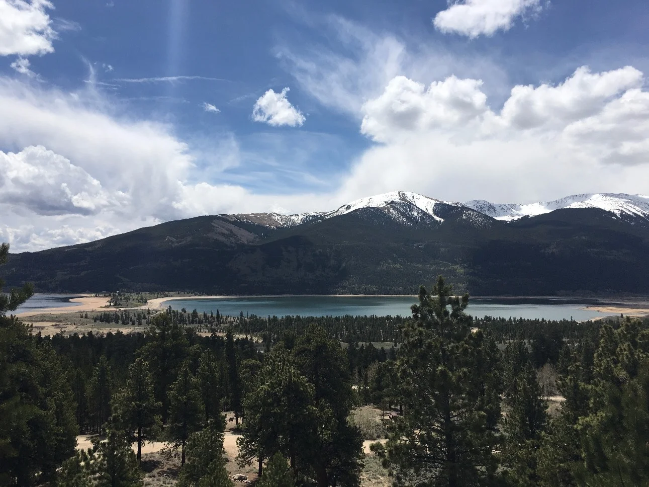
Twin Lakes Area Campgrounds
Twin Lakes Reservoir is located about 20 minutes south of Leadville. Follow US Hwy 24, then take Colorado Highway 82 a couple miles west. In the summer months CO Hwy 82 is open to Independence Pass and eventually leads to Aspen. There are 5 area campgrounds.
Lake View Campground
Note - Don't confuse this campground with the other Lake View Campground that is located in Gunnison County and overlooks Taylor Park Reservoir.
There are 8 loops in the campground. Each loop has it's own water station and toilet
- Loop A - 14 Sites
- Loop B - 5 Sites
- Loop C - 8 Sites
- Loop D - 7 Sites (Groups)
- Loop E - 13 Sites (Groups)
- Loop F - 6 Sites (Groups)
- Loop G - 8 Sites (No Reservations)
- Loop H - 10 Sites (No Reservations)
The almost 500 mile long Colorado Trail passes thru the campground and the South Elbert Trailhead is nearby.
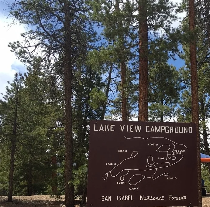
Lakeview Campground - Twin Lakes Colorado
White Star Campground
There are 3 loops in this campground located near one of the boat ramps at Twin Lakes Reservoir. An RV dump station is located outside the entrance. Elevation is 9200 ft.
Sage Loop
- Sites 1-28 (Reservations accepted for all)
- ADA Accessible Sites are 1-9, 11, 13, 15, 17-24, 26-28
- 5 Water Stations
- 3 Toilets
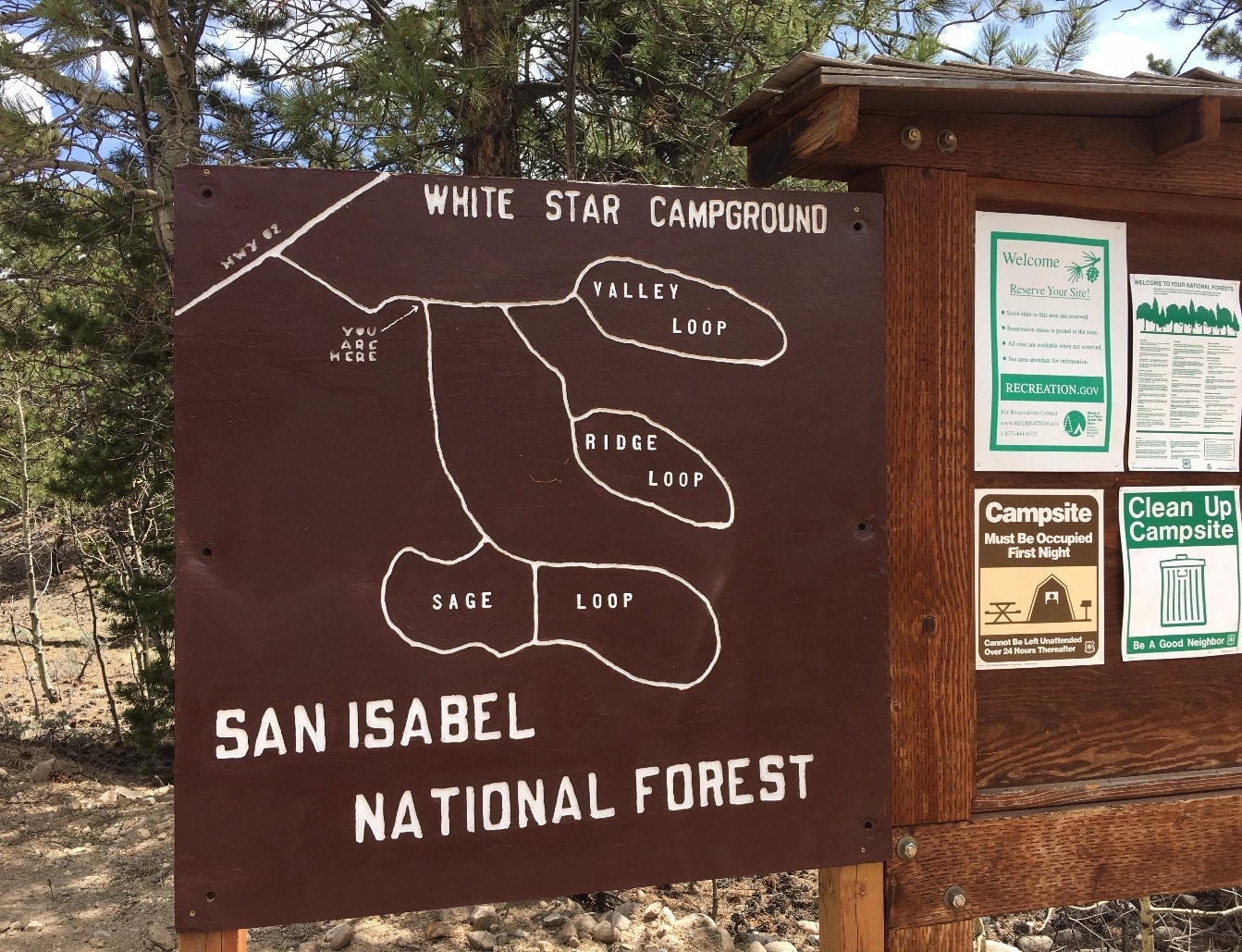
Ridge Loop
- Sites 30-45 (No Reservations accepted)
- Site 34 is ADA Accessible
- 1 Water Station
- 1 Toilet
Valley Loop
- Sites 46-66 (Reservations accepted for all)
- Sites 63-65 are tent only walk-in campsites
- 2 Water Stations
- 2 Toilets
Parry Peak Campground
Located in a forest of ponderosa pine 2.6 miles west of Twin Lakes Colorado on the road to Independence Pass. Lake Creek runs through the middle of Parry Peak Campground. All campsites are first-come, first-served.
Elevation 9430.
Weak cell service is available with Verizon and AT&T.
Twin Peaks Campground
Campsites are located in 2 loops on a ridge above Lake Creek. Most sites are in a shaded aspen & lodgepole pine forest at an elevation of 9600ft. Sites are first-come, first served. No Reservations accepted. Sites 1-11 are in the first loop and sites 12-33 are in the second loop.
Dexter Point Campground
A gravel parking lot next to the Twin Lakes Boat Ramp.